Chuseok Special Large-Scale Update
Enhancement of Detour Routes, Background Maps, and Complex Intersections
[Asia Economy Reporter Cha Min-young] T map Navigation has added a CCTV feature that allows users to check real-time traffic conditions, and various functions such as routes, background maps, and complex intersection images have been enhanced.
T map Mobility announced on the 15th that it conducted a large-scale update including these features ahead of the Chuseok holiday.
The newly included features are ▲CCTV service ▲Route service enhancement ▲Improved location positioning inside tunnels ▲Background map enhancement ▲Complex intersection image enhancement ▲Map style update, totaling six features.
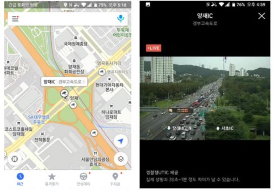
The CCTV service allows viewing screens from over 7,200 locations nationwide, including Ulleungdo and Dokdo. This is the largest number compared to other providers such as portals. Android smartphone users can access this by tapping the CCTV icon displayed on the T map application (app) map. The icon is displayed at the location of the filming target rather than the installation site, making it easier for users to understand the screen.
Route guidance will also be enhanced during the holiday period. Since traffic volume is heavy, the weighting of the previously provided optimal routes has been adjusted to show traffic routes specialized for the holiday. By analyzing detour route data from past holiday periods with large traffic volumes, the success rate was increased by about 46%.
The location positioning function inside tunnels is also improved. A technology that predicts the location of vehicles driving inside tunnels by utilizing various sensor information installed in smartphones has been introduced. This feature will undergo pilot testing this month and will be expanded to cover about 800 tunnels nationwide within the year.
In addition, background maps, complex intersection images, and map styles have been significantly strengthened. Detailed information on apartment complexes and hiking trails throughout Seoul, as well as major golf courses, is displayed. In apartment complexes, pedestrian-only roads and vehicle roads are distinguished, and underground parking lot entrances have been added to improve visibility.
Golf course bunkers, teeing grounds, course names, hiking trail shapes, required times, and hiking facilities have also been added. These will be applied mainly in the Seoul area before Chuseok and nationwide by the end of the year.
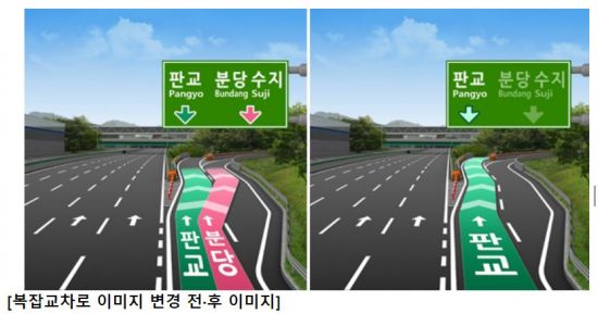
For complex intersections where continuous turns occur (such as ICs and JCs), enlarged intersection images have been improved so that drivers can easily understand the correct path, and the overall colors, font sizes, and icons of the T map have been improved to enhance visibility.
Kim Min-oh, head of the Data Intelligence (DI) group at T map Mobility, said, "Ahead of the Chuseok holiday, we have enhanced various functions so that drivers can use the T map service more conveniently. We will continue to add services focused on driver convenience to become the number one driving platform loved by drivers."
© The Asia Business Daily(www.asiae.co.kr). All rights reserved.
![Clutching a Stolen Dior Bag, Saying "I Hate Being Poor but Real"... The Grotesque Con of a "Human Knockoff" [Slate]](https://cwcontent.asiae.co.kr/asiaresize/183/2026021902243444107_1771435474.jpg)


