Expanded operation from 131 parcels to 237 parcels
[Asia Economy Reporter Jongil Park] Gangseo-gu, Seoul (Mayor Noh Hyun-song) is expanding the service that allows residents to check the exact boundary information of their land using a smartphone.
The purpose is to provide land boundary information to resolve land-related disputes that may arise between neighbors and to protect residents' valuable property rights.
The service, which was launched last year, provided boundary information for 131 parcels of land whose boundaries were determined through surveying such as registration conversion or land division over the past five years.
However, since this only targeted parcels for which land movement applications had been submitted to the district office, there were limitations to the information that could be provided.
Accordingly, the district office is collaborating with the Korea Land and Geospatial Informatix Corporation to additionally provide boundary information for 106 parcels across 12 neighborhoods including Hwagok-dong and Magok-dong.
Boundary restoration survey data related to building construction held by the Korea Land and Geospatial Informatix Corporation had not been disclosed until now, so neither the district office nor landowners could accurately confirm land boundaries.
To resolve this issue, the district office actively requested data from the Korea Land and Geospatial Informatix Corporation, resulting in the provision of boundary information for a total of 237 parcels, including the additional 106 parcels.
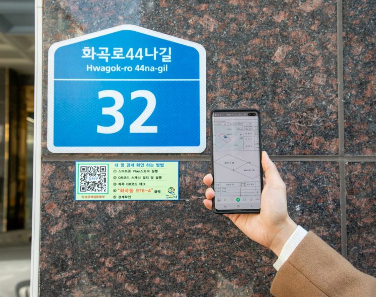
In particular, nameplates with QR codes are attached to parcels with buildings. By scanning the QR code on-site with a smartphone, users can directly check land boundaries through the Ground Boundary Point Registration data entered on the district office’s website.
For residents who have difficulty using QR codes on smartphones, the nameplates clearly display the boundary confirmation procedure in an easy-to-understand manner.
Also, anyone can easily check the boundaries of registered land by accessing the ‘Gangseo-gu Office Website Life Information - Gangseo Economy - Real Estate Information - My Land Boundary Information Service.’
The status of parcels with boundary information provided can be found on the ‘Gangseo-gu Office Website Life Information - Gangseo-gu Thematic Map.’
A district office official said, “This project is expected to greatly help protect landowners’ property rights by reducing the time and cost required to confirm land boundaries,” adding, “We will continue to expand the project so that various real estate-related information, not just land boundary information, can be easily checked.”
The ‘My Land Boundary Information Service’ was selected as an excellent case of proactive administration by local governments in the second quarter of 2020, hosted by the Ministry of the Interior and Safety.
For more detailed inquiries, please contact the Real Estate Information Division of Gangseo-gu Office.
© The Asia Business Daily(www.asiae.co.kr). All rights reserved.
![Clutching a Stolen Dior Bag, Saying "I Hate Being Poor but Real"... The Grotesque Con of a "Human Knockoff" [Slate]](https://cwcontent.asiae.co.kr/asiaresize/183/2026021902243444107_1771435474.jpg)


