Site of Joseon’s Top Administrative Agency ‘Uijeongbuji’ “Shows Diverse Historical Layers”
‘Geochang Geoyeolsanseong,’ a Battleground for Silla and Baekje Territorial Expansion “Key to Understanding Silla Fortress Changes”

‘Uijeongbuji (議政府址)’ located in Jongno-gu, Seoul, and ‘Geochang Geoyeolsanseong (居昌 居列山城)’ in Geochang-gun, Gyeongnam, have been designated as historic sites. The Cultural Heritage Administration announced on the 24th that, following the review by the Intangible Cultural Heritage Committee, the two cultural assets were registered as Historic Site No. 558 and No. 559, respectively.
‘Uijeongbuji’ is the former site of the highest administrative institution of the Joseon Dynasty. Through four excavation surveys conducted since 2016, the locations and sizes of the main hall Jeongbondang and the adjacent Seokhwakdang and Hyeopseondang were confirmed. The discovery of a pond, pavilion, and well ruins in the rear garden adds significant historical and academic value.
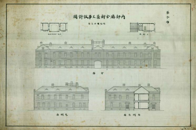 Blueprints for the construction of the new Internal Affairs Office building, estimated to have been created between 1909 and 1910
The Uijeongbu was the highest-ranking central administrative office of the Joseon Dynasty, holding the first rank (Jeong 1-pum). It oversaw all officials and managed state affairs. Since the late 14th century, when the Dopyeonguisasa (the highest state council in late Goryeo and the predecessor of the Uijeongbu in Joseon) was established on the east side in front of the palace, it was the only Joseon government office to maintain its original location.
The Uijeongbu was constructed in the 7th year of King Taejo’s reign (1398). It was built in a three-hall parallel style with a central building having a roof one level higher, flanked by buildings on both sides. Jeong Do-jeon described this in ‘Dopyeonguisasa Cheonggi’ as “The Dopyeonguisasa office building in late Goryeo had a tall and large central house, with wing-like houses on the left and right joined like hands (巍中翼拱左右).”
This architectural style was repeated when the office building was rebuilt in the 2nd year of King Gojong’s reign (1865). The Cultural Heritage Administration stated, “The central hall of the Uijeongbu in the three-hall parallel style, rebuilt, can be confirmed in photographs taken before 1901,” and “The building layout was also verified to match photographic evidence through four excavation surveys.”
The investigation team also confirmed the presence of brick foundations from the Gyeonggi Provincial Office building, which stood in front of the Uijeongbu site in 1910. The Cultural Heritage Administration commented, “The site hosted the Joseon Dynasty Uijeongbu, the Gyeonggi Provincial Office during the Japanese colonial period, the U.S. military government, and annex buildings of government offices, symbolizing various historical layers.”
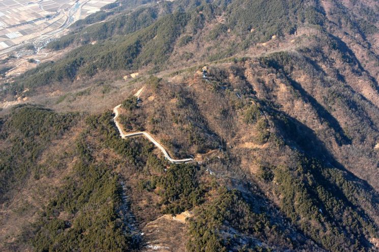
‘Geochang Geoyeolsanseong’ was a battleground for territorial expansion between Silla and Baekje. It is the largest fortress among those in the Geochang area from the Three Kingdoms period confirmed in historical records. The fortress is divided into the first fortress built during the Silla period and the second fortress expanded during the Unified Silla period. The Cultural Heritage Administration described it as “a key site that can reveal changes in Silla fortresses.”
The circumferences of the first and second fortresses are approximately 418 meters and 897 meters, respectively. Excluding the section inside the first fortress that is not connected to the second fortress and overlapping areas of the first and second fortresses, the total length is 1,115 meters.
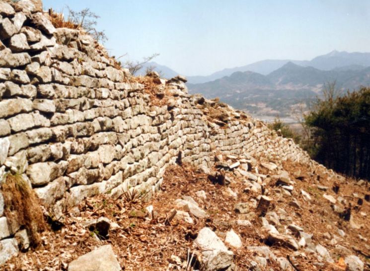
The first fortress was constructed in the mid-6th century as Silla advanced toward Baekje territory. It is presumed to be the ‘Geoyeol Fortress’ mentioned in the ‘Samguk Sagi (History of the Three Kingdoms),’ where 700 Baekje restoration army soldiers died. After Baekje’s fall, they carried out a restoration movement for three years but were decisively defeated in the 3rd year of King Munmu’s reign (663) by Silla generals Heumsun (欽純) and Cheonjon (天存) troops. The second fortress is identified as Manheungsasanseong (萬興寺山城), built in the 13th year of King Munmu’s reign (673) in preparation for the Silla-Tang War.
The Cultural Heritage Administration noted, “The water collection facilities located in the western valley of the first fortress and the eastern valley of the second fortress show differences in construction methods and structure,” adding, “These changes in fortress construction techniques provide important data for restoring ancient civil engineering methods and studying the history of water management.”
© The Asia Business Daily(www.asiae.co.kr). All rights reserved.
![Clutching a Stolen Dior Bag, Saying "I Hate Being Poor but Real"... The Grotesque Con of a "Human Knockoff" [Slate]](https://cwcontent.asiae.co.kr/asiaresize/183/2026021902243444107_1771435474.jpg)


