Influence on Jeju from the 6th... Strong Rain and Wind Nationwide on the 7th-8th
Developed to 56m/s on the 5th... Expected 40m/s Winds Upon Domestic Landfall
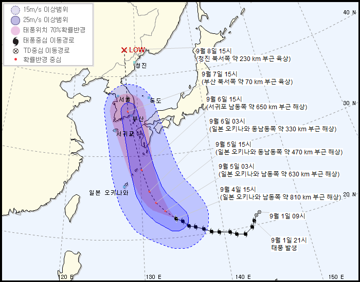
[Asia Economy Reporter Han Jinju] Typhoon No. 10 'Haishen' is expected to make landfall on the southern coast of the Korean Peninsula on the afternoon of the 7th.
The Korea Meteorological Administration announced on the 4th that Haishen is forecast to make landfall on the southern coast on the afternoon of the 7th and move northward through the central part of the Korean Peninsula.
Jeju Island will begin to be affected by the typhoon from the night of the 6th, and the entire country will come under Haishen's influence on the 7th and 8th. During these days, very heavy rain and very strong winds are expected nationwide.
As of 3 PM, Haishen is moving northwest at a speed of 17 km/h over the sea approximately 810 km southeast of Okinawa, Japan. The central pressure is 920 hPa, the radius of strong winds is 450 km, and the maximum wind speed is a very strong 53 m/s.
The typhoon is expected to develop into an ultra-powerful typhoon with a maximum wind speed of 56 m/s in the early morning of the 5th. The ultra-powerful category corresponds to the top 10% of typhoons occurring in the last decade, with maximum wind speeds near the center reaching 54 m/s (194 km/h).
Haishen is expected to weaken somewhat as it passes over Japan, arriving in South Korea as a strong typhoon with maximum wind speeds in the 40 m/s range.
The typhoon is forecast to pass over land about 70 km northwest of Busan at 3 PM on the 7th, then reach land about 230 km northwest of Chongjin, North Korea, at 3 PM the following day, after which it is likely to gradually dissipate.
The Korea Meteorological Administration emphasized, "Coastal areas may experience flooding due to storm surges, and very strong winds and very high waves are expected at sea, so thorough preparations must be made in advance to prevent damage."
© The Asia Business Daily(www.asiae.co.kr). All rights reserved.


