Cumulative Rainfall: Sunchang 539.0mm, Damyang 538.5mm Recorded
From Evening, Seoul, Northern Gyeonggi, and Northwestern Gangwon Under Influence
Tropical Depression Formed, Moving North Toward Korea
[Asia Economy Reporter Lee Hyun-joo] Heavy and intense rain is falling mainly in the southern regions, and the rain is expected to gradually expand to the central areas.
As of 1:10 PM on the 8th, the Korea Meteorological Administration announced that very heavy rain accompanied by gusts and thunder/lightning is falling at a rate of 30-50 mm per hour in Jeonbuk, northern Jeonnam, and Gyeongnam. Strong rain of 10-30 mm per hour is occurring in southern Gyeonggi, Chungcheong, Gyeongbuk, and the southern coast of Jeonnam.
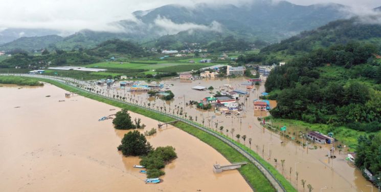
From the previous day until 1 PM today, the accumulated rainfall recorded was 539.0 mm in Sunchang, Jeolla Province, 538.5 mm in Damyang, and 484.5 mm in Gwangju. In the Gyeongsang region, rainfall reached 436.0 mm in Jirisan, 414.0 mm in Hadong (Hwagae), and 268.5 mm in Daegu (Seogu).
Very heavy rain will continue until noon in southern Chungcheong and southern regions, and from evening, very heavy rain of 30-60 mm per hour is expected in Seoul, northern Gyeonggi, and northwestern Gangwon Yeongseo.
This rain is in the form of concentrated heavy rainfall and has lasted for a long time, so the entire central region should prepare for safety accidents.
Additionally, a tropical depression in the eastern sea of the Philippines is moving northward toward Korea along the edge of the North Pacific High Pressure. Regardless of whether it develops into a typhoon, it may affect the area with rain or wind next Monday. If the tropical depression currently develops into a typhoon, it will be named Typhoon Jangmi, the 5th typhoon of the season.
© The Asia Business Daily(www.asiae.co.kr). All rights reserved.


