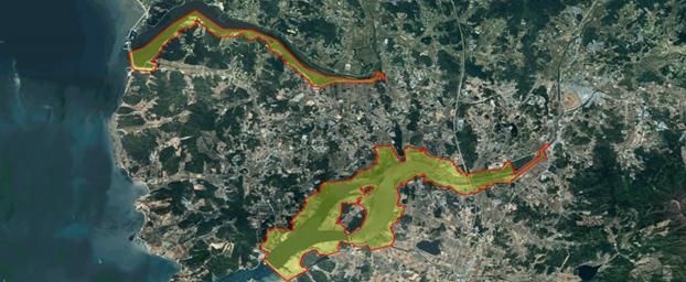
 Additional 12.5㎢ of land from reclamation of Boryeong Lake in Boryeong-si, Chungnam (Photo by Ministry of Land, Infrastructure and Transport)
[Asia Economy Reporter Moon Jiwon] It has been found that the national land area has increased by 821 times the size of Yeouido over the past 50 years. Roads and residential land have increased by more than 200%, while forests and farmland have significantly decreased due to industrialization.
The Ministry of Land, Infrastructure and Transport announced on the 3rd that it has published the "2020 Cadastral Statistical Yearbook" containing these details. Cadastral statistics are nationally approved statistics published annually based on land and forest registers, aggregating the total area and parcels of South Korea by administrative district, land category, and ownership type. The statistics were first compiled in 1970 and this year marks the 50th anniversary of their publication.
According to the statistics, as of December 31 last year, the total number of registered parcels nationwide was 38,993,000, with a total area of 100,401 km². Compared to the first cadastral statistics compiled in 1970, the national land area increased by 2,382 km², equivalent to about 821 times the area of Yeouido.
The increase in area is due to various development projects such as reclamation projects, agricultural development projects, and reclamation of public waters. Reclamation of public waters involves filling public water surfaces such as seas and rivers with soil, sand, and stones to create land, often promoted to establish industrial complexes.
Examining the area changes by major land categories over the past 50 years, forest and agricultural land (forests, dry fields, rice paddies, orchards) decreased by 5,386 km² (1,857 times the area of Yeouido). In contrast, residential land (residential, warehouse, factory land) increased by 3,119 km² (1,076 times Yeouido), and road and railway land increased by 1,878 km² (648 times Yeouido).
In terms of percentage, forest land decreased by 11.7%, dry fields by 19.2%, rice paddies by 11.7%, while residential land increased by 203%, roads by 215%, and railways by 155%.
Regarding this, the Ministry of Land explained, "Since the 1970s, with industrialization and urbanization, the use of national land in South Korea has changed along with the times."
Based on cadastral statistics, the metropolitan municipality with the largest area is Gyeongsangbuk-do with 19,033 km² (19.0%), and the local government with the largest area is Hongcheon-gun, Gangwon Province, with 1,820 km² (1.8%).
By land category, the category occupying the largest proportion in South Korea is forest land at 63%, followed by rice paddies (11.1%) and dry fields (7%). Forest and agricultural land account for about 81% of South Korea's total area.
The local government with the highest proportion of forest and agricultural land is Hongcheon-gun, Gangwon Province, where 92.6% (1,686 km²) of the total area is forest and agricultural land. The local government with the most residential land is Hwaseong, Gyeonggi Province (103 km²), and the area with the most road and railway land is Cheongju, Chungbuk (53 km²).
Looking at population density confirmed through the "Resident Registration Population Status" data provided by the Ministry of the Interior and Safety and cadastral statistics, among metropolitan municipalities, Seoul, Busan, and Gwangju had the highest population densities. Among local governments, the order was Seoul Yangcheon-gu, Seoul Dongdaemun-gu, Seoul Dongjak-gu, Seoul Jungnang-gu, and Seoul Gwangjin-gu. Yangcheon-gu, with a land area of 17.4 km², has a population of 458,165, resulting in a population density of 26,322 people per km².
Son Jong-young, Director of the Spatial Information System Division at the Ministry of Land, said, "We plan to distribute the cadastral statistics to about 280 institutions including public organizations, libraries, and schools so that they can be actively used as basic data in various fields such as land-related policy making, tax imposition, and academic research. We will continue to strive to produce accurate and reliable cadastral statistics."
© The Asia Business Daily(www.asiae.co.kr). All rights reserved.


