Seoul Gangseo-gu to Provide 'On-site My Land Boundary Information' from March; Land with Buildings Can Be Checked via Mobile Service QR Code on Smartphones
[Asia Economy Reporter Jongil Park] Gangseo-gu, Seoul (Mayor Noh Hyun-song) will provide a service from March that allows residents to check the exact boundary information of their land using a smartphone.
The district office creates a Ground Boundary Point Register, which includes location descriptions and photos of boundary points installed on-site when land boundaries are determined through surveying.
The Ground Boundary Point Register is an internal document and has not been disclosed to landowners or others, so even if landowners wanted to verify land boundaries, they could not know the exact information.
After much consideration to resolve such concerns of landowners, the district decided to provide land boundary information and proceeded with this project.
The land eligible for boundary information provision includes land whose boundaries have been determined through surveying in the past five years due to registration conversion or land division.
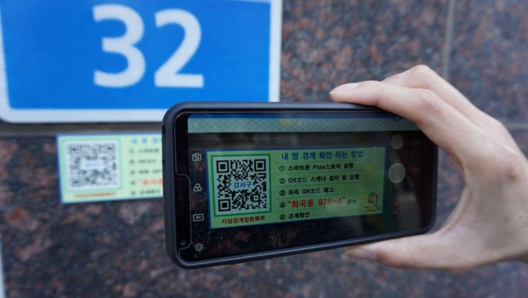
This service allows landowners and others to check their land boundary information on-site using a smartphone.
First, to allow anyone to check land boundaries, the district uploaded the Ground Boundary Point Register data created for each parcel over the past five years on the district website.
In particular, nameplates with QR codes are attached to parcels with buildings, and by scanning the QR code with a smartphone on-site, users are connected to the Ground Boundary Point Register data entered on the website to immediately verify land boundaries.
For residents who have difficulty using QR codes on smartphones, the nameplates clearly display the boundary verification procedure for easy understanding and access.
Also, anyone can use the service by clicking the ‘My Land Boundary Information Service’ banner under ‘Living Information - Gangseo Economy’ on the Gangseo-gu Office website.
Additionally, the district plans to provide land boundary information for areas where new cadastral records such as land registers and cadastral maps are registered due to urban development projects.
Mayor Noh Hyun-song said, “I hope this project will serve as an opportunity to resolve land boundary disputes among neighbors and protect residents’ property rights. We will continue to expand the project so that not only land boundary information but also comprehensive real estate information such as individual publicly announced land prices can be checked on-site.”
Gangseo-gu Office Real Estate Information Division (☎2600-6898)
© The Asia Business Daily(www.asiae.co.kr). All rights reserved.


