Layered Surveillance of Southern Jeju Airspace from the Slopes of Hallasan Mountain
Transmitting Direction, Distance, and Altitude Information for About 1,000 Flights Daily
The location, altitude, and identification information of aircraft detected by the Jeju Halla Radar are transmitted to air traffic control centers such as Incheon and Daegu. Air traffic controllers communicate with pilots based on this information. The Halla Radar plays a critical role in ensuring that aircraft fly along designated airways and that accidents do not occur in the southernmost airspace of the Korean Peninsula, which is surrounded on three sides by the sea.
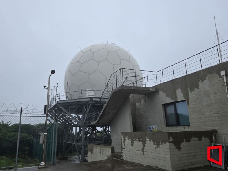 The Halla Radar located at an altitude of 1,138 meters on Hallasan Mountain in Jeju. Photo by Noh Kyungjo
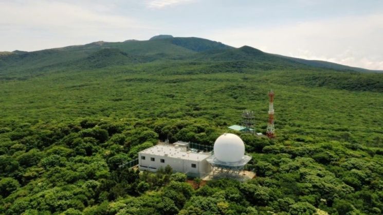
The Halla Radar base, which opened in December 2023, is located on the mid-slope of Hallasan Mountain (at an altitude of 1,138 meters) in Seogwipo, Jeju. When visiting by car on the 13th, it was a short drive past the 1100-meter rest area to reach the site.
After passing through the iron gate, a radar with an antenna, dome-shaped and rising next to a square office building, immediately caught the eye. According to the Korea Airports Corporation, this radar controls and monitors an average of 1,000 aircraft per day. This equates to 41 to 42 flights per hour, or about one flight every 1 minute and 30 seconds. Since its opening, the radar has monitored a cumulative total of about 540,000 domestic and international flights. The corporation explained that it is rare for a radar facility to operate at such a high level of activity.
Ko Cheolseung, head of the Jeju Aeronautical Radio Beacon Office at the corporation, stated, "The southern Jeju airspace is extremely complex, with five airways intersecting." He added, "The existing radar facility could not fully cover the southern boundary of the Flight Information Region with its radio waves, so the government installed the Halla Radar at a high altitude to address this issue." He also explained that, because the radar is located at a high elevation, it can monitor aircraft flying at different altitudes in the same area.
The southern Jeju airspace is where airways (Y711, Y722, B576) heading to China, Japan, Australia, Hong Kong, Taiwan, the Philippines, Vietnam, and the Middle East intersect with airways (A583, Y590) between China and Japan. In the past, this area was subject to the interests of Korea, Japan, and China, and, under the mediation of the International Civil Aviation Organization (ICAO), the three countries shared control of the airspace. However, as safety concerns increased under this system, known as an "air corridor" (airspace where flights were only permitted at specific altitudes), Korea took the lead in air traffic control in 2021.
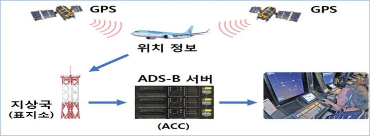 Operation sequence of Hallaradar Automatic Dependent Surveillance-Broadcast (ADS-B). Provided by Korea Airports Corporation
The Halla Radar is equipped with a three-tier surveillance system: primary surveillance radar (ARSR, which detects position and altitude through radio wave transmission and reflection), secondary surveillance radar (SSR, which identifies aircraft tracks through radio communication), and automatic dependent surveillance-broadcast (ADS-B, which detects various flight track information). In the case of ADS-B, aircraft use the Global Positioning System (GPS) to determine their own position and transmit location and track information to the ground at one-second intervals, which the radar receives.
Before the Halla Radar, the Donggwang Radar was used. However, the Donggwang Radar only operated SSR and was located at an altitude of just 348 meters, with obstacles such as Wonmul Oreum (Wonsu-ak) and Hallasan to the north and Sanbangsan to the southwest hindering surveillance. To address these shortcomings, the Halla Radar introduced the nation's first 3D radar, enabling detection of direction, distance, and even altitude.
Ko emphasized, "Not only does it provide accurate aircraft position information, but it also enhances control reliability by operating aeronautical mobile communication facilities and data link equipment, enabling both voice and data communication between controllers and pilots."
The Halla Radar base is staffed by six employees, who are well-prepared for Jeju's challenging weather, such as heavy rain or snow, which can make travel difficult. Due to road closures, they have to work consecutive shifts three to four times a year (averaging three to four days each), so they keep about 15 days’ worth of emergency food supplies. Water for daily use is collected rainwater, which is treated using reverse osmosis. Ko added, "We clean the septic tank once a year, and both wastewater and sewage are discharged into nature," noting that the local government inspects the facility annually.
© The Asia Business Daily(www.asiae.co.kr). All rights reserved.


