Seoul City Confirms Rapid Integrated Planning for 'Beondong 441-3 Area'
Low-rise residential areas in Beondong 441-3, Gangbuk-gu, Seoul, which have aged, will be transformed into a residential complex with about 950 households and a maximum height of 29 floors.
On the 27th, the Seoul Metropolitan Government announced that it had finalized the "Beondong 441-3 Area Rapid Integrated Planning" containing these details. The target area has a high proportion of old buildings (90.7%) and semi-basement houses (about 71%), and is located on a steep terrain at the foot of Opaesan Mountain (maximum slope 14%), making the residential environment poor.
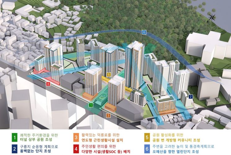
The city will first create a three-dimensional park connected to Opaesan Mountain within the complex to make the area a "forest zone" residential complex. The plan is to improve residential conditions by creating a large-scale park on top of the Opaesan Tunnel, which had previously been occupied by roads and parking lots that hindered the residential environment.
The pedestrian environment will also be made safer. Through a slope-adaptive land development plan, the city will minimize retaining walls within the area and consider vulnerable pedestrians by installing elevators and stairs. Additionally, the entrance path to Odong Neighborhood Park located on the west side of the area will be renovated into a pedestrian-priority road, and direct pedestrian access from the three-dimensional park within the complex to Odong Neighborhood Park will be provided. Public facilities, neighborhood living facilities, and small green spaces will be arranged along Deokneung-ro at the front of the area, and unavoidable level differences will be utilized for public and neighborhood living facilities to enhance residents' convenience.
Efforts were also made to create an urban landscape. An open view corridor plan linked with parks within the complex was established to allow views of Opaesan Mountain from major pedestrian streets such as Opaesan-ro and Deokneung-ro. To prevent the foot of Opaesan Mountain from being obscured, the eastern part of the complex was planned to have building heights within the elevation of Opaesan Mountain (123m).
Currently, the mixed-use zones within the area (Type 3, Type 2(7), Type 1 residential, etc.) will be adjusted to a single-use zone (Type 3 residential), and a flexible floor plan will be established to ensure consistency with urban planning while increasing project feasibility.
Jo Nam-jun, Director of the Seoul Metropolitan Government Urban Planning Bureau, said, "Although the area has poor residential conditions such as semi-basements, and there have been ups and downs in project promotion due to limitations such as the sloped terrain and the location of the Opaesan Tunnel, we hope that through this planning, the aging low-rise residential area, which was excluded from development, will be smoothly transformed into a pleasant residential complex with a three-dimensional park embraced by a 'forest zone.'"
© The Asia Business Daily(www.asiae.co.kr). All rights reserved.


