[Seoul District News] Yeongdeungpo-gu Provides Yeongdeungpo Olle-gil Timed Course Guide and Nearby Convenience & Safety Facility Location Info via District Office Website and Mobile App 'Trangle'... Eunpyeong-gu to Hold 'Walking Under the Moonlight' Event on 14th at 5:30 PM, 7Km Course Taking 3 Hours
[Asia Economy Reporter Park Jong-il] Just as there are Jeju Olle Trail and Jirisan Dullegil, Yeongdeungpo-gu in Seoul has the ‘Yeongdeungpo Olle Trail,’ where you can enjoy nature within the city.
Yeongdeungpo-gu (District Mayor Choi Ho-kwon) announced that starting in July, it will provide a GPS-based guidance service to promote the use of the Yeongdeungpo Olle Trail and enhance the convenience for residents.
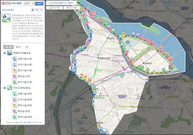
The Yeongdeungpo Olle Trail is a 19.5 km-long walking path consisting of the Yeongdeungpo Waterfront Trail along Dorimcheon and Anyangcheon streams, and the Yeouido Ecological Circuit passing through Hangang Yanghwa Park, Saetgang Ecological Park, and Hangang Yeouido Park. It is a popular spot where many people enjoy walking or cycling while admiring the beautiful waterfront scenery, with easy access to nearby parks.
Accordingly, the district has prepared a guidance service that includes detailed location information of the course routes as well as various surrounding facilities to make the Yeongdeungpo Olle Trail easier and safer to use.
First, the district conducted GPS surveying on 109 public facilities and made the acquired location information available for preview at a glance on the district’s website. By accessing the Culture & Tourism - Yeongdeungpo with Stories - Yeongdeungpo Olle Trail page via the PC version link, users can connect to the Smart Seoul Map to check course routes by section, find directions, and use other functions.
Additionally, information on convenience facilities such as rest areas, exercise equipment, and drinking fountains, as well as safety facilities including safe restrooms, Hangang police stations, basic number plates, and national point number plates for emergency location identification, is also provided.
Furthermore, the district has built a mobile service through a public-private collaboration with Beagle Co., Ltd. By searching for ‘Complete Yeongdeungpo Olle Trail’ on the application ‘Tranggle,’ users can follow the walking guide service while viewing their current location, record exercise distance and time, enjoy rankings among users, and access various contents such as completion certification and badges in a game-like manner.
The mobile service can be used after scanning the QR code nameplates attached to facilities around the Olle Trail, accessing Tranggle, and registering as a member.
Choi Ho-kwon, Mayor of Yeongdeungpo-gu, said, “We hope many visitors to the Yeongdeungpo Olle Trail actively use the newly established guidance service to enjoy more diverse and safer walks. We will continue to make various efforts to realize Yeongdeungpo as a healing city where all residents can enjoy rest, leisure, and a healthy daily life.”

Eunpyeong-gu (District Mayor Kim Mi-kyung) will hold a walking event called ‘Walking Together Under the Moonlight of the Northwest 3 Districts’ on the 14th, where participants can enjoy urban stories under the cool moonlight of midsummer nights.
The three districts of Eunpyeong, Seodaemun, and Mapo have come together to organize this walking promotion event to improve the health of citizens exhausted by COVID-19. Along with walking, an urban guide will share interesting stories about the city.
The walking event will start at 5:30 PM on the 14th at Exit 3 of World Cup Stadium Station. After a brief warm-up, the walk will begin at 6 PM and conclude at 9 PM.
The course covers 7 km and follows this route: Exit 3 of World Cup Stadium Station → World Cup Sangam Stadium → Maebongsan Observatory → Culture Depot → Metasequoia Road → Sky Park Observatory → Sky Staircase → Peace Park, taking about 3 hours.
An urban guide will accompany the groups, which will be divided into five groups for departure. The event offers ample rest and commemorative photos for each group, and participants can listen to hidden stories of history, nature, and culture along the course through the urban guide, providing a healing time for weary minds.
Stories will include why the Seoul World Cup Stadium was built here, the reason it was transformed into an ecological park, the origin of the name Maebongsan, and other place name histories.
Registration is open to 50 Eunpyeong-gu residents on a first-come, first-served basis, and participation is free. Those wishing to participate can visit the 1st floor fitness measurement room of the Eunpyeong-gu Health Center or apply via phone or the KakaoTalk channel ‘Eunpyeong-gu Health Center Exercise Life.’
Kim Mi-kyung, District Mayor, said, “We hope many residents exhausted by the heat will participate in this walking event where the cool breeze, night view, and stories blend beautifully under the moonlight.”
© The Asia Business Daily(www.asiae.co.kr). All rights reserved.


